|
Radar come in a variety of configuration in the emitter,
the receiver, the antenna, wavelength, scan strategies, etc. - (Wikipedia)
This category has the following 15 subcategories, out of 15 total.
E
M
P
R
|
R cont.
A
G
P
|
R
S
W
|
RADAR Installations
AUSTRALIA
http://www.absoluteastronomy.com/topics/Jindalee_Operational_Radar_Network
CHINA
NEW ZEALAND
- Birdlings flat radars - At Birdlings Flat we have four different types of radar systems. Loosely described,
these are a meteor radar system, a mesospheric radar system, an ionization radar and a tropospheric wind profiler. Read More...
Field Activities: The atmospheric
physics group maintains a number of radar facilities at our two field stations; Birdlings Flat and Scott Base. The Birdlings
Flat research site is situated near the southern end of Banks Peninsula on Kaitorete Spit about 45km south of Christchurch.
The department has had a presence there since 1961 when John Gregory’s partial reflection radar was moved from the Department’s
site at Rolleston. It was temporarily used for atmospheric soundings using rockets and has subsequently been known to locals
as the rocket launching pad. The site has had a progression of RADARs developed to study atmospheric and astronomical phenomenon.
Currently on site there are 3 main RADAR that probe various regions of the atmosphere from near ground level to over 100km
altitude.
Read More...

Photos: http://www.flickr.com/photos/7167305@N04/sets/72157604517690249/


RUSSIA
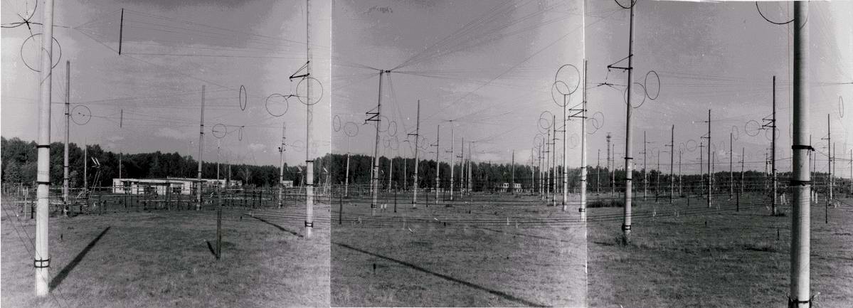
- SURA Official Site Russian - The Sura Ionospheric Heating
Facility, located near the small town of Vasilsursk about 100 km eastward from Nizhniy Novgorod in Russia, is a laboratory
for ionosphere research. Sura is capable of radiating about 190 MW, effective radiated power (ERP) on short waves. This
facility is operated by the radiophysical research institute NIRFI in Nizhny Novgorod. The Sura facility was commissioned
in 1981. Using this facility, Russian researchers achieved extremely interesting results regarding the ionosphere behavior
and discovered the effect of generation of low-frequency emission at the modulation of ionosphere current[1]. At the beginning,
Soviet Defense Department mostly footed the bill. The American HAARP ionospheric heater is similar to the Sura facility. The
HAARP project began in 1993.
Wikipedia: http://en.wikipedia.org/wiki/Sura_Ionospheric_Heating_Facility
Read more: http://lucianarchy.proboards.com/index.cgi?board=zorgon&action=display&thread=8872#ixzz1G9h2G1t5 
HAARP Like Facility, Nizhniy Novgorod, Russia +56° 7' 9.70", +46° 2' 3.66"
UNITED STATES OF AMERICA
WORLD WIDE INSTALLATIONS
From Wikipedia, the free encyclopedia
The Super Dual Auroral Radar Network (SuperDARN) is an international radar network for studying the upper atmosphere and ionosphere, comprising eleven radars in the northern hemisphere and seven in the southern hemisphere that operate in the High Frequency (HF) bands between 8 and 22 MHz. The radars measure the Doppler velocity of plasma density irregularities in the ionosphere.
In their standard operating mode each radar scans through 16 beams of azimuthal separation 3.24°, with
a total scan time of 1 min. Each beam is divided into 75 range gates of length 45 km, and so in each full scan the radars
each cover 52° in azimuth and over 3000 km in range, an area of over 4×10⁶ km².
SuperDARN began in 1983, when the first radar installation was constructed in Labrador, Canada.[1]
SuperDARN sites
The following is a list of SuperDARN sites, based on lists maintained by Johns Hopkins University Applied Physics Laboratory,[2] University of Saskatchewan,[3] and Virginia Polytechnic Institute and State University.[4] As of 2009, the network is expanding to the middle latitudes, including sites in Hays, Kansas (near Fort Hays State University), Oregon, and the Azores, in order to support mapping outside of the auroral regions during large magnetic storms.[1]
The list can be viewed here.
From Wikipedia, the free encyclopedia

EISCAT Kiruna Radar (diameter 32m)
EISCAT is an acronym for the European Incoherent Scatter Scientific Association. It operates
three incoherent scatter radar systems, at 224 MHz, 931 MHz in Northern Scandinavia and one at 500 MHz on Svalbard, used to study the interaction between the Sun and the Earth as revealed by disturbances in the ionosphere and magnetosphere. At the Ramfjordmoen facility (near Tromsø, Norway) it also operates an ionospheric heater facility, similar to HAARP. Additional receiver stations are located in Sodankylä, Finland, and Kiruna, Sweden. The EISCAT Headquarters are also located in Kiruna.
EISCAT is funded and operated by research institutes and research councils of Norway, Sweden, Finland, Japan, China, the United Kingdom and Germany.
In 2008, Doritos embarked upon an "out-of-this-world" advertising campaign, literally beaming a 30sec ad for Doritos brand
tortilla chips into a solar system 42 light years away. This project is in collaboration with EISCAT Space Centre in Svalbard. The "You Make It, We'll Play It" contest chose the winning advertisement that was transmitted on June
12, 2008. The ad was beamed towards a distant star, within the Ursa Major constellation, that is orbited by planets which
may harbor life.[1]
HAARP, Earthquakes, and Hurricanes
1) Mu Radar – 1 megawatt facility in Japan (34°51'14.80"N 136° 6'19.45"E).
2) Arecibo Observatory – 2 megawatt facility in Puerto Rico (18°20'38.97"N 66°45'9.77"W).
3) HIPAS – 70 megawatt facility east of Fairbanks, Alaska (64°52'21.18"N 146°50'18.78"W).
4) Sura – 190 megawatt facility in central Russia (56° 7'10.32"N 46° 2'4.41"E).
5) EISCAT – 1 gigawatt facility in Tromsø, Northern Norway (69°35'1.06"N 19°12'57.11"E).
(you can copy and paste the coordinates into google maps)

By comparison, HAARP (near Gakona, Alaska – 62°23'33.73"N 145° 9'2.61"W)
is claimed to be a mere 3.6 megawatt facility — and that’s after being upgraded in 2006. It has 278 times less
maximum power than the ionospheric heater in Norway.
http://montalk.net/conspiracy/142/ha%E2%80%A6and-hurricanes
School of Engineering & Mathematical Sciences
Tasman International Geospace Environment Radars
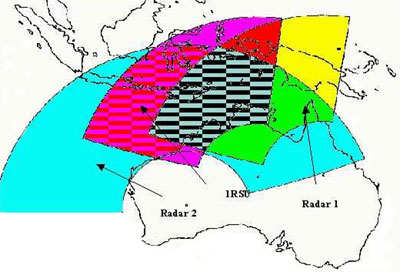
 TIGER is part of an international network of similar HF radars called SuperDARN (Super Dual
Auroral Radar Network) operated by ten nations to provide simultaneous coverage of both southern and northern polar regions. TIGER is part of an international network of similar HF radars called SuperDARN (Super Dual
Auroral Radar Network) operated by ten nations to provide simultaneous coverage of both southern and northern polar regions.
TIGER explores the impact of solar disturbances on Earth
by monitoring the location of aurora and related phenomena occurring in the ionosphere - 100 to 300km above the Earth.
It consists of two radars, one in Tasmania and one in New Zealand, with beams that intersect and explore
an area half the size of Australia. The radars direct HF radio signals via the ionosphere towards Antarctica and detect weak
echoes from structures in the ionosphere. These echoes are used to form images of the ionosphere structures and measure their
speed and direction of motion.
The radars also detect
echoes from meteors which are used to calculate wind speeds at heights of around 100km. Signals scattered from the sea are
also detected and methods of deducing the sea-state from these signals are being developed.
Results
from the operation of TIGER include greater knowledge of space physics and space weather processes which is required to improve
management of radio communications and navigation systems such as GPS. It also has relevance to satellite operations and magnetic
surveying for minerals and electricity supplies.
 When the sun's corona ejects huge amounts of matter that reach the Earth, there are rapid changes
in the wind speed and temperature in the ionosphere as well as the magnetosphere - that region where the Earth's magnetic
field interacts with the solar wind. When the sun's corona ejects huge amounts of matter that reach the Earth, there are rapid changes
in the wind speed and temperature in the ionosphere as well as the magnetosphere - that region where the Earth's magnetic
field interacts with the solar wind.
Auroras are caused by electrons striking
molecules and atoms after entering the Earth's atmosphere near the poles. The location of aurora can move 500 km in less than
a minute during magnetic storms and can disrupt communication and navigation systems. TIGER monitors such storms and can provide
real-time data on space weather storms.
TIGER is controlled remotely from La Trobe
University in Melbourne, Australia. It uses HF radio waves in the 8 - 20 MHz range. It consumes only 2 kW of power, the same
as some electric kettles and transmits an average of 200W - the same as two bright light globes.
TIGER
is supported by a consortium of institutions: La Trobe University, Monash University, University of Newcastle, Australian
Antarctic Division, ISR Divis
more here
http://www.tiger.latrobe.edu.au/
--------------------
|